MonsalPriestcliffeTaddington ChelmortonDeepDaleSterndaleMoorFlaggDeepDaleMonsalHead
23 rd January 2009
A pair of Deep Dales
Who Went: PNO, PH on pension duty much more important
Weather: Low cloud, sleet snow, hail, sun, wind, cold wind on tops, sun. We had it all. Snow was at around 1000ft in the morning but by the end of the day it had melted low down and the snow was above 1500ft.
Parking: Park on the road from Little Longstone just before the Monsal Head hotel. It's free and there are PC's in the car park by the Hotel. The charge per day for the car park is £4.50. Well done Derbyshire County Council everyone parks on the road even me.
The Walk
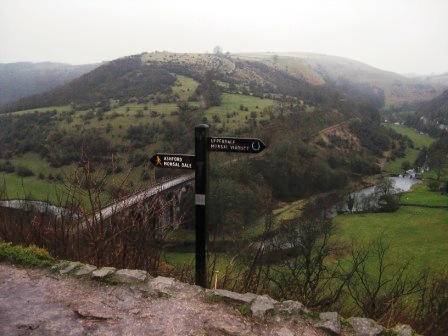
It was cold and grey as we set off. Walk up to the hotel, round the right hand side past the car park on your right to the head of the valley. The view is always stunning even when the cloud is low. I can remember as a young boy seeing steam trains coming out bf the tunnel and rumbling over the viaduct. Steam and smoke swirling around the valley and the shrill sound of the trains whistle as it announces it's about to enter a tunnel. It was a magical moment and the only reason I can forgive the railway companies for desecrating a wonderful valley. Still as you walk round these hills and moors there are plenty of reasons to ask for forgiveness. At its peak over 80,000 people were working in lead mines in Derbyshire. Many we will see today. The way we defend our countryside now is in sharp contrast to the wanton exploitation of natural resource that started over 200 years ago.
From the head of the valley descend diagonally right down a path (FP Upperdale/Monsal Viaduct) that takes you down to the near side of the viaduct that hangs below you. After descending some steps the path bends left (FP) and continues down through a wood to the end of the viaduct and just before the tunnel entrance, which is now blocked.
As you hit the Monsal trail turn right and cross to the far side of the viaduct.
Here turn left over a stile (FP Brushfield) and climb up on a steep rocky path which soon opens out into a track. After the gradient eases the track bends round the side of a disused quarry (although you wouldn't know it) and passes through a 5 bar gate.
The track follows the line of a wall (on your left) , passes through a gate opening and after passing through a second gate opening by a tree (FP) it leaves the wall and drops down to the top side of a wood where it passes through another 5 bar gate.
The track contours along the top side of the wood until it enters the yard of Lower Farm. A polite notice asks motor cycles to proceed with care they should be banned. Walk through the yard to a road at the far side.
Turn right (FP on corner Priestcliffe/Millers Dale) and walk up the road to Top Farm. The lane goes round the top side of the farm there was an old Standard 9 outside a barn and continues along the top edge of Hard Dale with good views over towards Taddington and the Moors beyond. Always keep on the main track; ignore a track that goes off right up the valley side and shortly after the track bends left and then divides take the left hand/main track which passes through a gate and climbs up to a point where it turns sharp left on to Bull Tor Lane.
This lane drops down to New Barn where the track turns sharp left onto Broadway Lane. In the distance you can see Priestcliffe. O.5km from New Barn take a track off left (FP) which drops down into a dip.
At a T junction with another lane turn right and walk up a shallow dry valley. Above on your right are the houses of and road to Priestcliffe. In 250 m you pass through a farm and continue up a walled lane which turns into a farm and climbs up to the bottom side of Rock Lodge Farm. Turn left along the bottom of the farm to a 5 bar gate (and PG) which gives access to a field. Walk diagonally left to a wall junction and follow the right hand side of a wall that climbs away from the farm. At the top of the field continue ahead and climb up to a wall (FP) giving access to the A6 opposite Taddington.
Cross the A6 and a stile walk along a path with a wall on your left to the bottom side of a church grave yard. Access the graveyard through a gate and walk to the front of the church then take the drive to the church gates and the main road through Taddington. At the gates turn right and walk up the road to a road junction. Turn left and immediately cross the road to a path (FP) between 2 houses. On the rhs of the path are high leylandi which will need cutting back in the summer.
The path leaves the line of the gardens (and the trees) and climbs up a field to a wall (FP) that gives access to Slipperlow Lane. Cross the lane (FP Chelmorton) and a stile and climb straight on a path to a wall (and a marker post).
The path continues to climb heading towards a mast which sits on Sough Top. Near the top you cross a further wall (FP); the finger was obliterated by snow. And then head for a wall junction with a covered reservoir on your right. Cross a wall via a stile with a 5 bar gate on your right and head diagonally right to the top right hand corner of a field; the trig point is over the wall to your right. Go through a five bar gate and follow the line of a wall (on your right).
You follow the line of the wall for 0.5km crossing a number of fields until you hit Sough Lane (FP). Cross the lane and continue following the line of the wall, past Fivewells Farm (on your right) until the wall you are tracking stops. Cross the next field to a gate which gives access to the top of the tarmaced section of Pilwell Lane (FP). Turn right, cross the lane and take the second path on the left (some 20m from where you hit the lane). There's a FP Chelmorton.
The path tracks down a thin field and eventually it begins to descend towards Chelmorton. As it descends you track round the side of the village church to the top of a metalled road which marks the edge of the village. Turn left down the road walking past the church on your left and the village pub on your left The Church Inn. As usual the pub was closed but this time for refurbishment. Just past the pub turn right up a good bridleway track (FP) between houses and walk out of the village towards Shepley Farm.
Walk past the farm (a FP keeps you on the correct track) with its chicken huts by the track (but no chickens) and up to Old Coalpit Lane.
From here the walk gets interesting. The walk down into Deep Dale passes ancient fields, and drops down into the dry valley of Marl Dale, before turning left past the monstrosity of a quarry and into the wonders of Deep Dale. But that's for the future. First cross the road and go straight along a track (FP) which quickly develops into a grassy track/path that shortly begins to drop down towards Burrs Farm and Marl Dale in the distance. Initially drops down along the left hand side of a wall, before it turns into a walled lane and then passes on the right hand side of Burrs Farm. After the farm the path passes through a couple of fields with a wall on your left before it hits a track. Walk down the track past a disused snow plough and as the track bends left go straight heading down the centre of the valley. It's interesting why a rust large snow plough is here. In the 60's a lot of the snow ploughing was done by contractors mainly farmers. They had tractors and lorries which could easily be converted into ploughs. They tooled themselves up. Some spent quite a lot on specific equipment, but as the winters got warmer one or two lost out money. The path follows the left hand side of wall into the mouth of the Dale. Suddenly, you are at Churn Hole and hit trees.
After crossing a stile you drop down sharply on wet slippery limestone into Marl Dale. Once down the sharp drop you follow the line of a moss covered wall down initially on its left then its right hand side until you hit the junction with Deep Dale and Topley Pike quarry with its fence. As we walked down the dale two ladies walked towards us with their dogs. The first of 4 ladies and dogs we saw in the day the only people we in fact met!
You would think you would know that you are at the confluence of 2 dales; but you don't. Deep Dale comes up on your right and should continue up to your left as a valley. It doesn't because the dale is blocked by a wall of earth (covered in trees and bushes) which forms a dam wall for the quarry. Trouble is this is not clear on the map which shows a deep valley going left and right. The wall turns into a fence the boundary to the quarry and by a wooden pylon there is a gate (FP). Turn left through the gate and you enter and area of special scientific interest; I find this somewhat ironic because of the impact the quarry has had on the area. Through the gate climb up the left hand side of Deep Dale until the path hits the boundary fence.
The path opens out to a track and begins to drop down into the bottom of the Dale. You pass a gate on the opposite side of which is the end of the dam, and a notice warning you of the danger of quick sands! Thought you only got these in deserts and bays; still man can do anything he chooses.
The track drops down to a gate which marks the end of the quarry and from the gate a path goes up the bottom of the valley, first following the left hand side of a fence which shortly turns into the remnants of a wall. The area is wooded and must be mainly in shade during the summer as everything is covered in moss. Down the valley bottom runs a stream resulting in a muddy slippery mess and on the steep sides are patches of scree which you cross interspersed areas of trees. The dale is one of the best in Derbyshire and in summer must a stunning place to walk with floral and wildlife.
But the best is to come. 0.9km after the dam at a bend in the valley you cross the Midshires Way and round a corner is a wonderful cave just off the path on your left which is well worth investigating. The path continues up the valley following the left hand side of a wall and passes the limestone outcrop of Raven's Tor on your right. 0.3km after Raven's Tor the valley splits and this marks the end of Deep Dale.
Take the left hand valley which is called Horseshoe Dale. As you walk up the bottom of the valley it gradually becomes shallower. After 0.75km Bullhay Dale goes off to the left but its private land and even though there is an interesting cave, notices tell you to keep out. It can't be farming land so why the landowner doesn't want people down there defeats me.
In another 200m you reach farm buildings; keep left through a gate and you soon hit the A5270 (FP). Cross the road and on the left a stile (FP) gives access to the continuation of the Dale.
Follow the line of the electricity pylons up the centre of the dale crossing a wall via a 5 bar gate. Keep up the middle of the dale. Near the top keep a walled off wooded area on your right and cross a wall blocking your path via a stile to the right of the line of the pylons. Cross the next field to the top right hand corner where a stile (FP) gives you access to the main road and lots of heavy lorries going to Hindlow Quarry which is ahead on the right. Turn left and walk up the road into the mining village of Sterndale Moor. You'll find it quite difficult to find a more bleak and featureless village in Derbyshire.
After the first couple of houses a path goes off left down a path (FP hidden by leylandi) between houses with our favourite leylandi on the right. The trees will be a problem this year. At the bottom of the gardens the path goes down the left hand side of a field with a few trees in it.
On your right is a children's playground and bleak houses; behind you are quarries, big quarries and Sterndale Moor, in all its bleakness.
At the end of the field you cross the line of a roman road you wouldn't realise it.
The path crosses the next field diagonally right to its top right corner, drops down through the next field to a 5 bar gate and then goes diagonally right to a stile in a fence. From here the path drops down into the bottom of a dry valley and climbs up to the end of a line of trees. A stile to the right of the trees gives access to a field. The path goes diagonally right passing the end of a wall on the right and heading diagonally right to the top end of the field by the end of a wooded area. From here the path drops down to the top right hand corner of a field which gives access to a road. Aim for the 5 bar gate.
As you come over the top of the hill and drop down the field ahead is the village of Chelmorton again; it was a good job PH wasn't with us as he would question our sanity in a 2hr diversion. The view is excellent and you can see the fine aspect of the church and vicarage.
At the road turn right and go straight across the cross roads.
In 400m as the road bends left take a path on the right (FP) that climbs up to a wall and then diagonally cross a field to a new fence (Stile) and up to the top right hand corner by some rocks. Cross the wall and follow the wall on your right. This drops down to Highstool lane(FP).Cross the lane (FP) and head diagonally right across the field. Note the map says you cross a wall on your right but the wall is not easy to see. If you go too far right you hit a wall which you should follow down to the top of the field by some old mine shafts as marked on the map.
Cross the wall and follow the wall on your left which drops down across two fields towards High Stool Farm.
At the top of the third field the path goes diagonally right heading towards a stile (FP) in a fence.
The route crosses two fields the worst fields I've ever crossed in my life. They had been cultivated and then cattle left to roam and eat the crops; in so doing they had churned the field into a mess. From the stile keep going ahead, cross the farm track and head for the bottom left corner of the field. In this field was the ugliest looking bull I've ever seen; it had massive horns like those in Wild West films. At the corner of the field turn left through a gate and into another field.
Follow the line of a wall (on your right) up to the farm entrance. Half way to the entrance the farmer was rebuilding a dry stone wall. She walked towards us with her two dogs; one of which was a large, and I mean large, black St Bernard. It saw us and ran towards us. Daisy the owner shouted is soft and friendly. It looked as if it was about to eat us but in fact was a big softy! Fancy calling it Daisy!
The path ends at the farm entrance which is at the junction of Main Street and Pasture Lane.
From the entrance turn left and immediately take a path off right (FP). The path crosses a number of fields running parallel to Flagg's' main street. Eventually ahead is a small coppice. Go to the right of the wood and immediately turn left and cross a field up to Main Road. Here turn right and walk down Main Street. Flagg is a nice village which is famous for its Easter Point to Point races. The weather always appears to be foul on race day. Walk to the end of Main Road where it bends left (opposite the junction with Mycock lane) and carry on straight past the pub to where the road splits.
Take the right hand road and in 100m turn left on a path (FP hidden by a tree) )that initially follows the right hand side of a wall down to the bottom of a field.
Cross into the next field and follow the right hand wall across 3 fields until it drops down to a road (FP). Cross the road and take a path ahead (FP) that climbs to a right angled wall. It continues along the left hand side of wall that climbs away from the right angle.
Cross another wall and head straight across the next field to the apex in the top wall. The path crosses the bottom of the next field and then climbs diagonally up the next field just to the right of some rock outcrops. Here we met our final lady walking a dog. Four dog ladies in a day! Cross the side wall and immediately turn left and cross another wall. From here walk to the top right hand corner of the next field and this gives you access to Flagg Lane. Turn right, cross the road and in 100m turn left down Wheel Lane.
Drop down the lane to the top of Deep Dale. Here turn right through a gate and start the descent of Deep Dale to the A6 some 1.5km away.
The path initially follows the left hand side of a wall but in 300m there is no access down the left side and you cross to the right hand side and the mud. There's a stream and mud, not a pleasant path but a lovely valley. In spring and summer it's full of flowers the trouble is I've never seen them because the call of the high moors is greater than the fauna of Deep Dale.
As you approach the bottom of the Dale the path turns right and away from the wall. After a couple of hundred meters it turns sharp left and drops down to the wall and stream. Cross both and take the path ahead that shortly hits the car park. Walk through the car park and cross the A6.
From the road (FP) drop down and cross a stream. Take a path/ track that follows the left hand side of Wye River.
In the twilight of dusk the valley is a magical place. The silent flow of a full river is constantly providing a calming atmosphere in the deep tree lined valley.
For over 1km you walk round a right hand bend in the Dale before it bends left and there ahead of you is the Victorian viaduct below Monsal Head. 300m before the viaduct take a path off left hat climbs up to the western end of the viaduct (FP).
From here turn right and cross to the far side of the viaduct and in front of the blocked tunnel entrance take the path off left (FP) that climbs up to Monsal Head.
Walk round the right hand side of the Hotel and ahead is the road to Little Longstone and the car.
Summary
It's a good walk. The 2 Deep Dales are worthy of the walk in themselves.In spring and summer they are full off flora and fauna. It was a day when we saw little wildlife and 4 ladies walking dogs - tells you something about the walk.
It was a day that saw sleet, snow, hail and rain. At the highest points we had snow underfoot but by the afternoon the cloud had lifted and we saw some sun. Even though the temperature never got above 3C by the end of the day the snow had melted. The moors around Buxton had a significant amount of snow. Nothing much changes. On the higher and more exposed moors the wind chill was significant but you only had to drop down into a dale and the temperature rose significantly.
Home Start Point Peak District Books Related Sites Text Only Map&Summary
Home Start Point Peak District Books Related Sites Text Only Map&Summary