WestendAlportCastleFarmOysterHigherShelfBleaklowHeadNearStonesBarrow Westend
23rd May 2008
Grand Views and Peat Moors
Who went: PNO, PH on pension duty, DG on holiday
Weather:Sunny periods turning to high cloud and spitting with rain. Cold and breezy on top
Parking: Park on the side of the road just before the bridge and the gate that gives access to the valley track. Don't block the gate as it is used by forest workers. SK154927
The Walk
Walk through the gate ahead of you that gives access to Ditch Clough Plantation. The track soon crosses the Clough and then take a track off to the left, P&NFS to Alport Castle .
The track climbs up through the wood. In the spring sunshine it's a lovely climb with shafts of light coming through the pine trees. After the previous week in the Lakes this climb felt easy.
Eventually the track exits the wood (NT Birchinlee Pasture) but continues to climb.
To your right good views of Westend valley open up, while on your left is Ditch Clough. The track climbs through a line of grouse butts until you hit the eastern edge of the Alport valley just to the north of Alport Castles.
The views of the valley with Bleaklow at its source, of Alport Castles and Kinder to the south are well worth the climb.
At the edge, turn left (South East) and follow the edge round. Ahead you can see the path heading down on the far side of the Castles. If you miss the path you will hit a wall, look below you and you can see the path you need. Turn right, drop down to the path and turn left and descend down a steep descent to Alport River .
Initially you follow the line of a fence/wall (on your right), which you cross (the wall is now on your left) and then cross again. After the second crossing, you follow a fence down (on your right), which turns north, and shortly afterwards you pick up a fence on your left which marks the boundary of Castles Wood. Continue to descend.
The gradient gets steeper after a P&NFS sign.
Eventually you reach the footbridge across the Alport. On the far side turn right and track the river until the path climbs up to and crosses a fence. The path now heads to a gate in a wall on the lhs of Alport Farm.
Track round the side of the farm and shortly a stile gives access to the farm track. Turn left and walk down the farm track. On your left there are good views of Alport Castles.
After 1.25km you will see a FP pointing to a path on your left and immediately after this a fence comes up from the left and tracks the lhs of the track.
Shortly afterwards the track bends round to your right and below you can see Hayridge Farm. Immediately on your right take a path at a WM post. The path tracks across a field, above the farm, to a fence which is crossed via a stile.
As we contoured above Hayridge Farm PNO was stopped by the farmer, as he climbed the fell on his quad rounding up his sheep and lambs. P knew him. He was one of 2 brothers who had taken over the farm from their father. P asked if he was still lambing. Nearly finished he said as the lambs bounced around.
The path continues to track above the farm to the edge of a field, where you turn right and ascend along a track with a wall on your left.
As we climbed up the track in a gully beside the wall, we were faced by a fierce looking black bull in front of us. It turned to face us. P shouted to him to get out of our way. After some thought and a few large thumping noises from our chests the bull turned and went up the path. P's view is to out stare them and shout at them to get away. Eventually the bull went up the side of the fell and off the path; we walked nonchantly past him (sure I can hear you say). We kept looking over shoulders to ensure he didn't charge. We were grateful to see the gate and safety.
The track tracks round the top of a wood and crosses a clough before heading straight to a wall and tracking the wall (on your left) as it climbs up to a stile (NT The Knots). The path now follows the right hand side of a wall as it contours round The Knots and Cowms Moor. At the second wall you cross there is an NT Sign (Cowms Moor).
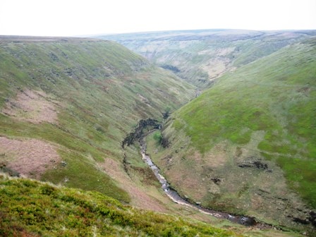
Eventually the wall drops left and down the fell. You keep straight and contour round the fell side, crossing a fence via a stile as you enter the bottom end of Oyster Clough. Ahead you eventually see the V shaped valley of Oyster Clough . The path drops down to and crosses a fence via a stile and then follows a wall (on your left) which drops down to the stream in Oyster Clough. There is no path up the bottom of the valley.
Ahead there is a path which appears to climb up the side of the valley to meet the path which contours the top of the Western side of Clough coming from Birchin Clough. However, the path is faint and steep and occasionally we could see a black pipe. Bit of a give a way as the path led to a small stream where the pipe was fed from the stream via a plastic container. The path stopped but we could see where the path was that we were heading for so we climbed up the side of the valley to the path. It was somewhat steep and not easy going in the Bilberry covered moorland.
Turn right on the path and contour round to the shooting cabin at the top of the Clough. From the back of the cabin a path takes you to the Clough grain. This time we took the left hand grough and climbed up to the line of grouse butts.
Follow the line of the butts and when they run out head for the last stake. From here a path takes you to the top of the moor and as you climb the views of Bleaklow opens up on the horizon to your left. There were lots of curlews and lapwings around Oyster Clough and on the top - Hope Forest . The moorland is heather with clumps of cotton grass.
However, at the top of the fell the moor turns into groughs. Here, turn left and head slightly west of north.
Ahead you can see the weak line of a grough that develops into a stream, turns North West and that takes you to Nether Reddale Clough. All on the tops the cotton grass was coming out.
At Nether Reddale Clough turn right north east - and walk down the Clough. There is a path of sorts. You need to be on the left hand side of the Clough (north side).
As the Clough starts to drop down into the Alport Valley keep to the edge of the moor where the grassy lower level meets the peat groughs. Eventually you hit the edge of the Alport Valley and from here a good path takes you north and up to Grains in the Water.
The views of the Alport valley and its waterfalls are wonderful; it's the best side of the valley.
The path along the edge is relatively easy to follow. Initially it climbs as you walk round Alport Moor, then as the path descends to the river at the Grains, it becomes more indistinct.
Head for the stile in the fence on the northern side of Hern Clough. It's easy to see in the distance when you get to the Grains. From here you join the path that descends the eastern side of the Alport Valley.
Cross the stile and ascend on a good path the northern side of Hern Clough. At the top of the Clough you hit the Pennine Way at a small stone pillar. Here, the Pennine Way and Hern Clough turn north.
However, we head straight and almost due east on a good path that ascends round the top of Crooked Clough, onto the moors where they are trying to stabilise and reseed the heather.
Near the top you pass the extensive wreckage of a Super fortress.
Then in front of you is the white trig point that marks the top of Higher Shelf Stones.
The views of Doctors Gate, Glossop and beyond are worth the effort in getting there provided the mist isn't down.
If the views are poor its still worth looking at the graffiti chiselled into the rocks. Some may object but they will remain there for centuries; but please don't add anymore.
All across Bleaklow grouse scuttled off rather than flew away as we walked the moors. They circled round as we walked not making a noise. Clearly they were guarding their young in their nests. In addition there were lots of plovers singing away.
From here there is some moor tramping, which in dry weather is a pleasure; if it's wet well that's a different matter. Looking north, right, the fell rises to Wain Stones which you can see on the horizon if it's clear. At first you can take a path that heads east of north but this path eventually follows the course of Dowstone Clough. As the path starts to head off westward down the Clough keep east of north and ascend up the peaty moor side heading for the Stones. To your right you can see Hern Stones. Again the National Trust et al are reseeding the moor and stabilising it to prevent further erosion. The moor has cloudberry and bilberry sprinkled all around plus cotton grass; but we were too early for the grasses to be at their best.
Eventually you hit Wain Stones.
From here head north east, passing a couple of cairns and eventually you stumble across the large cairn topped with a pole that marks Bleaklow Head. Because of the nature of Bleaklow the views are not impressive but the moonscape of the surrounding landscape is memorable on your first visit.
From here the way ahead is north east. At first you can follow a path but this soon turns north and heads down Near Black Clough. But our route takes us to Near Bleaklow Stones.
To get there you have to cross some of the best landscape on the Bleaklow plateau. At best in dry weather it is like a peat desert with the sand dunes substituted by rolling dunes of peat in between which are dry groughs. In wet weather it is a soggy mass and hard work to cross. Once you leave the path you circle the top of Near Black Clough ascending gently. Eventually the gradient flattens out and you leave the peat behind.
Ahead you cross a grassy, bilberry covered yet sandy terrain and ahead of you there is Near Bleaklow Stones A bit of a disappointment really, except for one thing. There were dozens of hares on Bleaklow near Near Bleaklow Stones. Never seen as many. They were in various stages of transfer from white to brown. But they were certainly active. Mad May hares!
The views from the Stones are extensive if a little bleak wonder how it got its name? You can certainly pick out Bleaklow Stones and Barrow Stones in the distance it worried me how far away they appeared but you needn't worry.
From Near Bleaklow Stones head south east traversing round the top of Middle Black Clough. Initially the going is quite easy but as you near Bleaklow Stones you hit peat groughs. However, on the skyline, to your right (due South), you can see the boundary stakes that traverse the Bleaklow plateau.
Head for these, then turn left and follow the stakes and a path that leads directly to Bleaklow Stones. As we got there, 3 blokes appeared having ascended from Swains Head at Bleaklow Stones quite a surprise - and then further on a bloke at Barrow stones. The Stones here are much more impressive than Near Bleaklow Stones. And the views are better.
From Bleaklow Stones the going gets easier, with the next destination being Grinah Stones, which can be seen in the distance. They are very impressive and represent the eastern end of the Westend Valley . A path heads slightly north of east (to the right of Grinah Rocks) descending down at first then contouring round the top of Deep Grain.
The path is good and easy to follow even in bad weather and eventually climbs to Grinah Stones. From the Stones you can't appreciate their scale because they are below you and there is nor evidence from the tops of how impressive they are. The best view is from where you have just come from - Bleaklow Stones; but it has to be a clear day.
From Grinah Stones head East of North up a grough; half way to Barrow Stones we found P's patch of Labrador T.
Keeping on the same bearing, we then found a cross/plague announcing the source of the Derwent.
A short distance from the cross you hit the northern end of Barrow Stones. Over the decade/centuries, a number of people have taken a hammer and chiesl and cast their intials for posterity. Now there is more recent chiselling circa 2003 (using a power tool by the looks of it) but it is far less extensive than that on Higher Shelf Stones.
From here head south to the southern end and Crown Stones.
Find the gate in the fence, below the Stones on your left, that gives access to a good path heading south east to Round Hill. The path descends at first and then flattens; the path is well defined across the heather clad moor. Round Hill is marked by a large cairn.
From Round Hill turn right (east of south) and a good path descends down the Hill onto the flat top of Ridgewalk Moor. At the bottom of the descent you join a track form the right that comes from Grinah Stones. Keep east of south and head down the flat top of Ridgeway Moor. It's a wet path that is easy to follow.
After just over 0.5km you hit the track running NE/SW from Lower Small Clough over to the Westend Valley . When you hit the track, turn right (SW) and walk down a good track that takes you down into Westend Valley . Just as you start the descent take time to go off right to a small cairn. This marks the spot where the MP the Right Honourable Mark Balfour collapsed and died. . A shooting party, including the MP had one drive on Ridgewalk Moor and were moving across the moor to Round Hill and the shooting cabin in Lower Small Clough he never made it and the birds had the afternoon off. P was beating on tops. They were waiting for the signal to beat but it never came. They saw people gathered round and eventually a helicopter came to take the MP to hospital. The shoot was called off and beaters got 1 days pay for ½ days work. The birds lived to fly another day.
From the top of the moor a good track takes you into Westend Valley and begins to descend down its eastern side. As you descend, the views down the forested valley are good. Eventually, at a sharp bend you hit a gate (NT Ridgewalk). The track continues to descend through another couple of gates until it eventually enters the wooded bottom of the valley. P tells a story of when he was a youth helping the game keeper in Westend Valley. The Forestry Commission were trialling different types of fencing materials and the blokes came every year for many years to assess performance. You can still see the different fencing materials 40 years later on the left of the track, at the forest edge, as you descend the valley. Past the last gate was a Forestry Commission vehicle and on the opposite bank a man working on fencing.
As you get close to the river, take a path/track off to the left that takes you to a footbridge. There are bird boxes under the bridge; but we couldn't see any inhabitants. The bridge used to give shooting parties access to the Moor but it has been deemed unsafe now for the heavy vehicles and their occupants.
Cross the bridge and turn left. The walk down the bottom of the valley is beautiful on sunny days at this time of the year. Sun streams through the canopy above, the river gurgles away and the birds are in full song. Who'd rather work? Not I. The track takes you right down to the road and the cars.
Summary
A grand walk with good views. There was lots of wildlife and the moor was sprinkled with flowering cloudberry, green blueberry plants and cotton grass. The birds were nesting and guarding their young.
The route is in general easy to follow, the exceptions being on Hope Forest Moor and the track from Higher Shelf Stones to Bleaklow Head.
The weather was excellent for walking. Sunny periods with a nice breeze on the tops.
Home Start Point PeakDistrict Books Related Sites TextOnly Map&Summary
Home Start Point PeakDistrict Books Related Sites TextOnly Map&Summary
 .
.