KettlewellGreatWhernsideBuckdenPikeBuckdenOldCoteMoorKettlewell
16th March 2007
Who went: DS, DG
Weather: Overcast at the beginning of the day with Great Whernside and Buckden Pike just out of the cloud. The cloud dropped during the day and from10.45 there was intermittent rain
Parking: Car park on lhs as you head up the valley after the road bridge over the Wharfe just as you enter the village. It's at the back of a garage
Car Park cost £3.00 (NB now it is £3.20)
The Walk
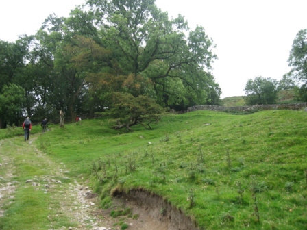
In the car park, head towards the village/toilet. At the car park entrance turn left.
Ahead the road divides.Take the rh road sign posted Scargill House and walk past The Smithy. Ahead on the skyline is Great Whernside.
The road meanders through the terraced houses of Kettlewell with the steam on your left.
Walk up the road until it divides; take the left hand branch. This tracks the bank of Dowber Gill Bank (on your lhs). Nb the rh branch goes off to Scargill House.
The road passes the Kings Head Pub, passes a road bridge on your lhs and passes a church on the rhs. Shortly on the rhs is a FP indicating the route of the Dales Way ; ignore it.
Carry on up the road. A track goes off right to Rain Slack Well, ignore it and carry on straight, FP (Hag Dike1.25m & Providence Pot 1.5m). The road turns into a track and eventually divides. Take the left hand track and immediately cross the beck.
Immediately after the bridge turn right and walk up the rhs of the beck; FP (Hag Dike1.25m & Providence Pot 1.5m), with a wall on your lhs.
In 50m the path crosses the wall on your lhs via a gate; FP (Hag Dike 1.25m)
A good path now starts the ascent of Great Whernside following a wall on the lhs of a field.
As you ascend, the path moves right and away from the wall and crosses another wall at the top of the field (FP Footpath) via a stile.
As you climb look back at the view - it's worth it.
The ascent continues through grazing fields and a further wall is crossed via a 5 bar gate with a small side gate, followed by another wall which is crossed via a gate opening or a ladder stile to its rhs doubt if anyone uses the stile.
After 15 minutes of ascent the gradient suddenly eases off at a finger post ( which when I did it had fallen over and lay on the ground)
Ahead is the whale backed shape of the western side of Great Whernside.
To the right is Dowber Gill Beck, with Providence Pot at its head. The way ahead is clear
The path contours then rises gently towards the escarpment behind Hag Dike, first crossing a fence/wall via a gate. The path then follows a wall (the wall is on your rhs), then a wall is crossed via a ladder stile and finally a third wall is crossed via a gate. The gradient begins to increase and a FP (Foot path) is passed before a further wall is crossed via an opening. Finally the path climbs to towards the buildings at Hag Dike.
Just before the buildings the path hits the road access track to Hag Dike. Here turn right and pass through a 5 bar gate FP Coverdale road via Great Whernside.
The track leads to the house with the path passing to the right hand side of the house through a gate.
At the back of the building immediately turn left and climb up a rocky path which initially runs up the back of the house but soon leaves it behind.
The path is more like a Lakes path as it ascends up to the top of the escarpment, where you meet a couple of cairns
Here the gradient drops with a clear path ahead which is marked by a series of 5 yellow capped posts spaced up the fell side. Towards the summit the gradient increases and the path becomes more rocky.
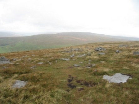
Out of the gloom the cairn marking the summit sits on top of a rocky outcrop
The views from the summit on a clear day are well worth the climb
At the summit cairn turn left, (north) and follow the edge via a weak path until you hit a yellow capped post.
The path now drops down below the edge and contours under the edge following a line of yellow capped posts (5 in total) on a weakish path that would be difficult to find in snow.
At the last post the path begins to descend first to a wall, crossed via a gate, and then drops down Black Dike to the Coverdale Road . The path is wet and boggy but easy to follow.
As the gradient lessens an area of shake holes are passed. The path crosses a wall, via a gate, tracks a wall (to the left of the path) for a short distance before heading for the Coverdale Road , FP (Scar House Lodge 4m)
The way ahead used to be over private land and a bit of trespassing to Tor Meer Top, but the land is now open access with stiles on the fences! Take a good path that heads for Tor Meer Top (North East). The track meets a fence, which is easily crossed, and from here the path heads up the fell. The path ascends and hit another fence at a junction with a second that heads up the fell.
By now the weather was deteriorating and over- trousers were needed. Cross the fence and track the second fence up the fell (on your lhs).
The fence turns into a wall and at Top Mere meets a wall running north / southish from Buckden Pike to Starbotton Peak Ground. Here turn right and follow the wall on its right hand side towards Buckden Pike. The path is wet and boggy and follows the wall until it meets the track from Starbotton to Walden Moor.
The cloud was down and from here to the top the views were limited.
Where the path meets the Starbotton track there is a boundary stone and the wall turns sharply and the path tracks the wall ascending away from the Starbotton track to the memorial cross for Polish aircrew killed during the 2 nd WW. One crew member survived by following the tracks of a fox off the fell
Once at the cross the main climbing is now over and the path tracks the wall along the flat top of Buckden Pike to the summit
The walk to the summit always amuses The Dog. In wet weather it is always wet and once when we got here on the same walk he decided to cross the wall and track it on its lhs considering drier. I went on the rhs and ended up with wet feet as I chose the wrong place to cross a damp area. He never ceases to remind me of the fact whenever we are on Buckden Pike.
Access to the summit trig point/ cairn is gained by crossing the wall (on your left) via a ladder stile.
With your back to the wall (trig point in front of you) turn right on a good path (FP Buckden) that heads north and then NW descending rapidly on the lhs of the wall. As we dropped down and out of the cloud, the views of Upper Wharfedale open out with Yockenthwaite Moor in front of you.
After dropping down the steepest part of the descent, the path heads of south west descending over wet grassy fell until you cross a wall via a gate.
The path descends further with Cray on the rhs crossing 2 walls then dropping to a third wall (crossed via a gate). The path eventually drops down to the Cray/Buckden track. Here turn left and go through a 5 bar gate FP (Buckden/Buckden Pike/Cray High Bridge).
The track contours before descending (wall on rhs) to Buckden.You enter Buckden via the car park at a gate (FP). We had lunch in Buckden.
Drop down to the main valley road. At the road turn right down the rhs of the village green following a wall on its lhs, until in 50 m you hit the road to Hubberholme. Turn right along the road, cross the Wharfe and turn left on a track that leads to Redmire Farm (FP Litton). Cross the cattle grid and take the track that winds up the fell side.
The track climbs up to a wall at a wood. Access a sheep dipping area via a 5bar gate.
Walk through the complex and gain access to a track on the far side via another 5 bar gate. The track continues to climb with a wood on you lhs. This track continues to contour but we take a path that goes off right (FP) and heads up Birks Fell.
As the path ascends don't head for the building ahead, but take the path marked by a series of stakes (heading south west) that climbs steadily and diagonally left up the side of the fell; the ground is quite boggy.
As you climb look back across the valley at Buckden Pike .
Near the top the path has been flagged to prevent erosion of the wettest part. By now the cloud was down again so there were no views from the top. As the gradient eases the path crosses a wall via a gate opening and follows the lhs of a wall until you hit another wall running along the top of the fell and running NE/SW).
Turn left and walk along the wall heading SE, shortly the trig point is on the left some 50m from the wall.
Carry on following the wall along the top of Old Cote Moor heading SE towards Kettlewell.
The wall takes a sharp left turn then shortly the way is barred by a second wall which has to be climbed ( NB there is now a stile 30m up the wall on your left i.e. NW). Turn right and head SE tracking the wall which is on your rhs.
The path is good. As you descend off Old Cote Moor you cross a wall and fence via stiles until from the right a ladder stile crosses the wall ( path from Arncliffe to Starbotton) Continue along the wall until you hit a second ladder stile that crosses the wall ( Arncliffe to Kettlewell path).
Turn left away from the wall and begin the descent to Kettlewell along a grassy path. The path hits a track from the left and descends along it for a while.
Across the valley are grand views of Great Whernside
When the track turns right and heads towards a wall on your right you keep descending. Eventually the path hits the wall on your right and crosses it via a stile.
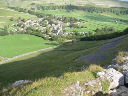
The path continues to descend steadily to the top of the limestone Gate Cote Scar.
As you descend the views up Wharfedale on a good day are magnificent.
From the top of the scar you can look down on Kettlewell and see the path off the scar down to the village. The path descends via a crack, which is slippery in the wet and can sometimes be difficult to find. At the bottom of the crack the path crosses some scree and from here the gradient eases. At the top of Gate Cote Scar was a group of men (and dogs) at the start of a weekend in the Dales, then below at the wall we came across a group of couples. They inconveniently held up the descenders by taking a group picture and blocking the stile
The path descends to a wall and then continues down the fell side to a good track running NW/SE from Kettlewell to Starbotton. Turn right on the track and shortly you go through a 5 bar gate and descend to the main road from Kettlewell to Grassington. At the road turn left, cross the road bridge and shortly turn left into the car park.
Summary
A good walk, the views being spoilt by the weather. It was windy, wet and cold. We came across people on Buckden Pike and near Kettlewell, but no one else. The paths were wet but easy to find. DG walked away from me on the ascent up Old Cotes Moor, but she said that she had struggled up the ascent of Great Whernside
Home Start Point Dales Books Related Sites TextOnly Map&Summary
Home Start Point Dales Books Related Sites TextOnly Map&Summary
plus pics from walk on 14th September 2007


.