KingsShepherdMeetingRoundWoodheadNearBlackBleaklowHeadStonesBarrowWindyKings
17 th Oct 2008
True Delight for those that love High Moors
Who went: Self, with pathetic excuses: PH receipt of a kitchen, DG library visit, JK in Ireland PNO in Greece
Weather: Cloudy with sunny periods. Some threat of rain; cool. Ideal walking weather.
Although there had been a week of little rain in Worksop, it was wet underfoot and the paths had puddles. It had clearly rained in the past 24hrs. The moors were sodden.
Parking: Park at Kings Tree. It's free but get there early as places are limited and you can't go past Fairholmes by car at weekends or on Bank Holidays. But who wants to go up there when there are 100's out. PS I used to go then but in the twilight years don't have to
Suumary First
A wonderful walk that I had been planning for weeks but hadn't done because others wanted to come out. The path from Shepherds meeting Stones to Featherbed Moss I had been unable to find previously and there was no path form Featherbed Moss over Round Hill to Lady's Cross. Things didn't turn out quite like that.
Moors are magnificent. The autumn colours show them off at their best. Bracken was brown; trees on the lower slopes had gone golden brown, rustic red and yellow. The UK is wonderful at this time of year especially when the autumn sun pours down at a low angle highlighting detail that you don't see at the height of the summer sun.
Cloud was still on the top of Bleaklow as I reached the top of the Derwent valley but as I climbed away from the bottom it lifted, never to return completely. On Round Hill looking over to Bleaklow there was a hint that the cloud may come down but by the time it was time to climb up Near Black Clough the cloud had disappeared. It tried to return on the traverse from Bleaklow Head to the Stones but I was too quick and although there were some drops of rain it kept dry all day.
The rivers were full but not swollen; the ground was wet and the paths full of puddles. Most were muddy, especially the path up near Black Clough. The crossing of Bleaklow was sludgy. It was certainly drier than it has been in the past.
There were lots of wrens, crows, the occasional skylark and plover. A kestrel was out hunting on the moor tops and on Bleaklow I disturbed at least three hares in their summer coats. I came across one having a drink in a grough and was within 10 ft of it when it saw me and bounded off. I wish I was as agile as he was!
Unusually the only people I saw were 4 blokes - all my age. One on the TPT trail heading away from Woodhead; the other 3 were all on Bleaklow. The first was dressed in his winter gear with gloves on as I was heading away from Bleaklow Head with just my base layer I could see my breath. Shortly afterwards along came a grey headed guy who asked if he was far from the Pennine Way. He was heading for Crowden. I pointed out how to get to Bleaklow Head and pointed to the stake marking the summit cairn. The last guy was at Bleaklow Stones and was sitting down having refreshment. He asked what time it was. People astound me. May be I'm too conservative but I would not go on moors without maps and a watch.
A true Needham walk. Mainly high lonely moors with route finding reasonably easy; but you could see where you were going. I'd forgotten how easy it is to traverse from Bleaklow Head to the Stones. You can always see the stakes as they are generally on the silhouetted on the skyline. For some distance you can see the distinctive outline of Bleaklow Stones.
The moors were wet and sticky and in places distinctly gooey but my feet remained dry. The views were good but you couldn't see the Snowdonia because of the cloud and the late afternoon haze.
Descending down Black Dike the old legs were tired from all the efforts on the tops. Tired they may have been but the body was happy and the mind was exhilarated. High moors are not everybody's cup of tea, but I love them. It's difficult to explain why. Most people think they are featureless and boring but they forget these very attributes give them a fascination because few people venture over them so they become quite havens away from the masses on The Ridge, round Grindsbrook or in the Dales of the White Peak. Here you meet more hares than people and those that you do see appear as eccentric as you. Mostly they are single males perhaps that says it all.
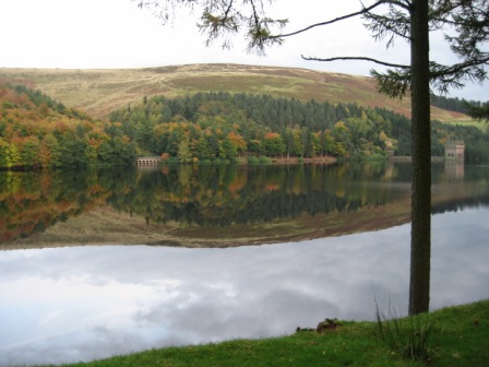
Finally on the last stretch just before I hit the road to Kings Tree a low pitched drone started from up the valley and got louder; it wasn't the distinct thump of a Lancaster but then above the trees was what I think was a Hercules. It was big and green and was about 100ft above the Derwent. A couple of seconds later and it was gone. As an appendix the drive down the valley was wonderful. The sun was out and just before the wall of Derwent dam the water was flat and mirror like. On the far side the trees were autumnal yellow red and brown; and reflected in the water. Beats New England any time. A fitting end to a great day well at least I thought it was a great day
And what of the walk.
The Walk
It didn't start well. I nearly left the map in the boot in fact I started off without it and after 10mins checked and went back for it - I thought I hadn't taken my spare batteries and first aid kit, but found I'd carried them around all day in the bottom of my sack. I got caught short after 15mins which caused a further delay. But on the plus side my boots were dry, I didn't go wrong, found that there was a path between Featherbed Moss and Round Hill which wasn't on the map but the path from Shepherds Meeting Stones to Featherbed Moss doesn't appear to exist.
Leave the car at King's Trees walk up the road to the tree, through the pedestrian gate and onto a good track that takes you to the lovely bridge at Slippery Stones.
Cross the Derwent and turn left, shortly cross Cranberry Clough by the footbridge and keep left heading up the right hand side of the Derwent valley on a good track that is only for walkers.
In the autumn sun the walk up the Derwent valley is one to be savoured. The trees had turned golden brown, red and yellow, the bracken was brown and the heather had lost its purple haze.
You cross Broadhead and Stainery Clough, before the path heads down close to the river.
As you walk up the moors enclose you and suddenly after crossing Lands and Coldwell Cloughs you turn a corner and the valley begins to open out as you approach its head.
On your left is Barrow Clough and above it Barrow Stones with the cloud just lifting off it and above you on your right are unnamed rocks ending in the distinct Hoar Clough with Shepherd Meeting Stones on its left. Just before the Clough turn right and ascend up the right hand side of the Clough through bracken.
As you reach the top of the edge a path crosses the Clough and goes up to the back of the Meeting Stones but as usual I kept on straight following up the rhs of the Clough. There appeared to be a path but it disappeared as the Clough split into two. Both the Cloughs were reedy so I crossed to the left hand bank and then walked up the lhs of the left hand branch. There was no path but keeping to the edge of the Clough the heather was shorter. A couple of side Cloughs are crossed - they were deep and very wet in the bottom. At the top of the third side Clough there was a path that headed up towards the skyline. Never wanting to miss an opportunity I followed it. The gradient is shallow, then on the skyline you can make out a cairn. The path was heading for it but suddenly at a grough the path disappeared.
Continue forward across water sodden moor to the cairn and the path from Howden Edge to Swain Head. On reflection and looking at the route I took, I was somewhat off the intended path. I should have taken the path to the meeting Stones and then looked for a path going off to the right. I've been there a couple of times and not managed to find it. The route I took was OK and not too difficult. You need to find the cairn as from here a good path heads north east to Round Hill. The route is easy but the moor is waterlogged.
From Round Hill continue north east to Lady Cross. At Lady Cross turn left on the old Manchester to Doncaster pack horse track.
The track is easy to follow, becomes the Trans Pennine trail (meeting a bridle way from Dunford Bridge) and crosses Salter Brook on a nice stone bridge. It's a pity that the ale house that stood by the bridge is a ruin. A pint would have been welcome. The track crosses the Woodhead Road and lots of traffic the drivers look at you gone out.
Good progress is made on the trail as it heads west above the Woodhead road. On the opposite side Bleaklow looks imposing and the three Black Cloughs are clear.
Just before Woodhead turn left on a track (FP) that heads back down to the road, which is crossed and then drop down to the River Etherow.
Before the tunnel turn left and cross the river via a bridge and then head up the far side (right hand side) of the river heading south east towards Near Black Clough.
The first Clough you meet joining the Etherow is Near Black Clough the largest of the three Black Cloughs. Turn right and follow a good track up the rhs of the Clough. Soon take a path that climbs up through a wood and away from the stream, up to a track that leads to a promontory above the wood overlooking the Etherow.
Turn sharp left and take a path that tracks up the edge of the Clough and initially above the wooded area. The path is easy to follow and very muddy. It's a nice climb up for about 4/5 km to Bleaklow Head. You keep to the rhs of the Clough which heads mainly south west for most of the way to Bleaklow Head.
Eventually the path drops down to the Clough, turns south and shortly you realise you are on the plateau and into the grassy groughs. The path runs out at the top of the Clough and you need now to head east heading keeping a close eye on the gradient and heading towards the highest point.
Soon the gradient flattens and you see the stake and cairn of Bleaklow Head. It will not be easy to find your way to the top in mist because the good path up the Clough disappears, like many others on Bleaklow, near the top. The view, as always, are worth the climb and are even better if you go to Wain Stones.
From the summit cairn head south of east towards a stake. This marks the start of the traverse of the southern edge of the Bleaklow plateau. It goes through the wilderness of peat hags and groughs. In wet weather it is tough going in the sticky slime. Personally, it is one of my favourite places. Follow the stakes down to a group of 2 large stakes and a smaller stake. Here turn left and head north east, and then turn right and head due east following the lines of stakes along the southern side of the Bleaklow plateau.
Ahead, on a good day, you soon see the distinctive shape of Bleaklow Stones in the distance. On a clear day the route finding is easy. It's not as easy in the mist as the stakes are not so easy to see when visibility is limited.
The eastern end of Bleaklow is marked by Bleaklow Stones. The views from here are worth the effort. Due east is Grinnah Stones and below you to the right is the basin of the Westend valley. On the far horizon you can make out the distinctive rocks of Back Tor.
From Bleaklow Stones descend slightly right of straight and take the main path that heads off round the top of the Westend valley to Grinnah Stones. There are 2 paths heading towards Grinah which both meet up eventually ,but take the left or higher path. The trek round to Grinnah is easy to follow and eventually you arrive at the top of the Stones. It always surprises me how unspectacular these Stones look when you arrive at them. From Bleaklow they are so grand.
From the top take a path heading north east and contouring along the edge to Crown Stones. Head just to the right of the Stones as here a gate through a fence gives access to the path that drops down to Round Hill.
The route is now easy to follow. From Round Hill it drops down heading south east onto the water sodden Ridgewalk Moor. After dropping down to the Moor you join a path from the right from Grinnah.
For the next 4km you head straight for Back Tor on the far side of the Derwent Valley, first on Ridgewalk Moor then after hitting the shooting track above Lower Small Clough, you follow Black Dike.
Always keep to the top of the ridge; a couple of times a side dike falls off to the left, but if you keep to the main dike heading down the spine of the moor you will eventually hit the remains of a wall that heads down to a wood Nether Wood Plantation.
Gain access through a gate onto a track which drops down to Windy Corner. Here turn left and walk up the valley road to Kings Tree. Watch out for the motorists who think they own the place.
Home Start Point PeakDistrict Books Related Sites TextOnly Map&Summary
Home Start Point PeakDistrict Books Related Sites TextOnly Map&Summary